Arctic Environmental and Engineering Data and Design Support System
About this tool
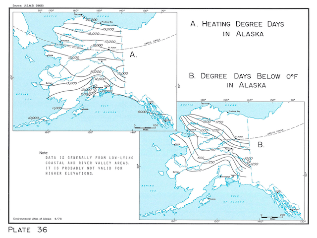
In the late 20th century, the need for accessible environmental information tailored to engineers and decision–makers, led to the publication of the Environmental Atlas of Alaska. The publication compiled maps of the best data available at the time. The Atlas provided a well–organized overview of the physical characteristics of the state alongside its waters, sunlight, and general climate. This was paired with engineering requirements and guidelines, as well as a thorough bibliography.
The Atlas ages
Over time the Atlas’ shortcomings became clear. Data gaps frustrated engineers and planners not working along the state’s road systems or rivers, and presented particular challenges to engineers in the far north and west. Complex topography, particularly in Southeast Alaska, also made coarse–scale maps imprecise. The data also assumed a steady climatic state while modern data tells a more detailed story—one of significant change.
A path forward
Alaska’s infrastructure must be robust to support the economic, defense, and social needs of a state experiencing a changing climate. Arctic Environmental and Engineering Data and Design Support System (Arctic-EDS) was created to replace the aging Environmental Atlas of Alaska while addressing the old atlas’ shortcomings by providing finer scale data, filling data gaps, and incorporating climate projections. The Arctic-EDS provides easily obtainable, well–vetted, and reliable engineering and environmental data in a central website designed to meet the needs of engineering professionals.
Improved historical data allows this site to provide a more detailed picture of Alaska’s climate history. Modern climate science also allows the Arctic-EDS to make informed projections about the future of the state’s climate over the lifespan of Alaska’s infrastructure. Finally, the integration of functional modules, a data API, and Python notebooks allow for easy integration of Arctic-EDS data into modern engineering workflows relying on computer programs.
The tool, built by the team at the University of Alaska Fairbanks Scenarios Network for Alaska + Arctic Planning, is under active development. The Arctic-EDS team comprises experts from the University of Alaska Fairbanks’ International Arctic Research Center and Department of Civil, Geological, and Environmental Engineering; alongside experts from the University of Alaska Anchorage; the Cold Regions Research and Engineering Laboratory; Neptune, Inc.; and Lawrence Berkeley National Laboratory.
Thank you to our funders
Funding comes from the Environmental Security Technology Certification Program, an environmental technology demonstration and validation program of the United States Department of Defense. The team is grateful for ongoing support and feedback from the United States Army Corps of Engineers.
License
Unless otherwise specified by source providers, all data available through this tool is available through the Creative Commons Attribution 4.0 International (CC by 4.0).
Rasdaman raster database
This tool uses the rasdaman array database management system. This technology enables our team to store, analyze and visualize the 5+ TB of climate data that are presented through this interface. We wish to thank the rasdaman project and team for their inspiration and support, and for providing this important innovation in data technology.
Peter Baumann, email: p.baumann@jacobs-university.de, & website: rasdaman.org. (2018). rasdaman - raster data manager (9.5.0). Zenodo. https://doi.org/10.5281/zenodo.1163021